| 540 | Trail Sense Basic Map and Compass |
2011-12-19 |
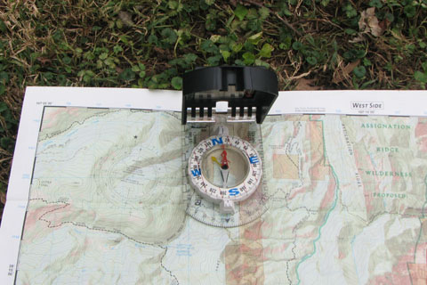
The compass rose is to the left of the compass
I run the streets of our neighborhood on most days of the week. It is surprising, how many times I am stopped by motorists asking for directions (by the way, it is very inconsiderate to stop a runner to ask for directions - even a slow one ... but that's another story). No one has ever said to me, I cannot find 'this place' or 'that place' on my map, or 'this place' is not showing up on my gps. It would be easy to show the driver where the location was on a map; but I have never met a lost driver that had a means of navigation with them. They just want directions. They want someone to tell them how they should go.
Through the years in the outdoors, I have also met quite a few people on and off the trails who were lost or did not know where they were. The common factor of the lost motorists and the lost hikers is that neither group used aids to navigation. They are lost for a reason! Of course there are those who carry a map and compass and still get lost. There is not much difference between a hiker who does not use the map and compass because they left it at home, than the one that leaves the map and compass in his pack because he doesn't know how to use it.
We have been talking about navigation over the last few weeks including : Where Am I?, Where Am I Going?, and How Do I Get There?
The most basic navigational skills are finding north on the compass and orienting a map to north.
On a topographic map, north is the top of the map (north up). Beware, I have seen several park maps that are not 'north up' - but I think they were more artistic maps than topos.
On a compass, the needle points to magnetic north (MN). The difference between magnetic north and true north is declination.
The topographic map lists the angle of declination and whether it is east or west. The declination is shown on the compass rose imprinted on the map.
Declination changes. In 2010 the line of zero declination followed the Mississippi River.
East of the Mississippi, the angle of declination is West and a degree.
West of the Mississippi, the angle of declination is East and a degree.
On the compass, adjust the angle of declination by moving the adjustable declination arrow (which most modern compasses have) or, put a small piece of tape on the bottom of the compass to match the angle of declination.
Adjusting the compass takes only a few seconds and then it is done.
In Nashville the declination is currently -3.4 degrees or 3.4 degrees west. Mark the compass with the piece of tape or with the adjustable arrow for 3.4 degrees less than 000 or 360 (356.6).
If Magnetic North was to the east, the angle of declination would be added, i.e. +5 degrees east declination - add 5 degrees
When reading the adjusted compass, read the bearing directly off the compass ring - it is already adjusted!
Now that the compass is adjusted, orient the map by changing the angle of the map so that north on the compass and on the map (top of the sheet - north up) are both pointed to the same angle. The map is then oriented.
The oriented map allows you to look at the terrain and features on the map and in the field - all in the same view. If you see a distinct mountain in the distance a few degrees to the east of your position; then look on the map a few degrees to the east and find the name of the mountain.
Orienting the map is fairly simple but it does take practice to gain confidence in the techniques.
Happy map orienting trails