| 952 | South Mount Elbert Trail East Ridge Route |
2014-09-03 |
After finishing the Mount Elbert Map and the guide to the North Mount Elbert Trail for cloudhiking.com, we were trying to decide what was next ... I couldn't find some map data for a Teton trail, so by default we decided to complete Mount Elbert with the guide to the equally popular South Mount Elbert Trail.
The South Mount Elbert Trail has two trailheads. The Lower South Mount Elbert Trailhead is located just off Hwy 82 - the road crosses Independence Pass to Aspen. It is adjacent to Lakeview Campground. From the Lower Trailhead a 4WD road (FSR125.1B) travels 1.85 miles to the Upper South Elbert Trailhead. The route description begins from the upper trailhead.
After a short section of the Colorado Trail the South Elbert Trail starts climbing the mountain. At about 1.60 miles from the trailhead, tree line is reached and the views begin. After crossing to the north for 0.60 miles the East Ridge is reached. The South Elbert Trail is also called the East Ridge Route. It is 2 miles to the summit with great views almost every step of the way.

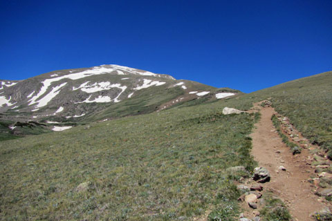
East Ridge from the Lone Boulder
A few South Mount Elbert Trail notes ...
The South Mount Elbert Trail and North Mount Elbert Trail are very similar. If four wheelin' is part of the game to you, then the South Trail is probably a good choice, but if you shun walking on dusty 4WD roads, the North Trail is probably a better choice.
The route is easy to follow (except for maybe through the snow on the upper slopes - if it is present).
The trail sees a lot of use. One of the reasons we were not really excited about the route after first completing it, was all the crowds. Start early and avoid the crowds and the afternoon storms.
Please practice minimum impact usage. Stay on the trail and off the fragile alpine tundra.
Once on the East Ridge it seems but a short distance over to the Northeast Ridge and the North Mount Elbert Trail.
There are no false summits on the South Elbert Trail. What you see is what you get, even though there is a lot of it!
From the Upper Trailhead it is 4.2 miles to the summit and from the Lower Trailhead it is 6.05 miles to the summit. ( The North Mount Elbert Trail is 4.8 miles to the summit.)
Of course you could do the 'tour de Elbert' and go up one route, down the other, and return via the Colorado Trail for a 12.9 mile loop.
There is no reliable water on the route except for the creek that is crossed on the Colorado Trail just beyond the Upper Trailhead.
Both routes are fun, but require the hiker to be in good shape, acclimated, and carrying the appropriate gear for the changing conditions.

Final Climb to the Saddle of the Summit Ridge
Make plans to hike Mount Elbert. It is worth the effort. So please visit cloudhiking.com and check out the new South Mount Elbert Trail guide, the North Mount Elbert Trail and the Mount Elbert map. Thanks.
Happy Mount Elbert trails
Mount Elbert Map and Trail Guide
Mount Elbert -'14 - trip report