| 976 | South Rim Trail |
2015-02-19 |
Last week, August (pup) and I visited Savage Gulf Natural Area to hike the South Rim Trail. We started from the Savage Gulf Trailhead located off Tennessee State Highway 399 and hiked about eight miles to Stagecoach Road and then returned by the same route.
August is becoming a good hiker and companion on the trail. His only problem is getting to the trail. He has issues caused by motion sickness, car sickness, and/or nervousness. Whatever the reason, he loses his cookies (or actually kibbles) on car rides. When we arrived at the trailhead, I had to spend a few minutes cleaning up after our poor pup.
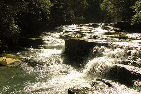
Savage Cascade just above the Falls
Soon we were on the trail. This was my first visit to the Savage Gulf Trailhead. August and I were both excited as we walked briskly down the trail. After crossing a couple of bridges we were at Savage Falls, a wonderful cascade and drop. After letting August wade through the frigid water, we were hiking again.
The South Rim Trail was very similar to the Big Creek Rim Trail that we had walked the week before. Both trails traveled to the edge of the gorge (actually called a gulf) to overlooks and then away from the edge to cross drainages.
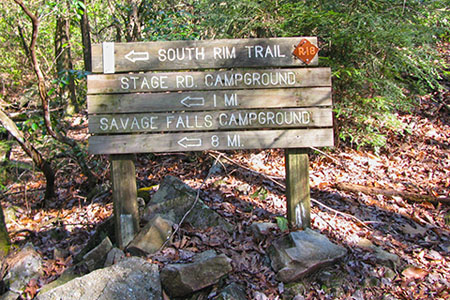
South Rim Trail sign at Stagecoach Road Tr
We took a short break at Stage Road Campsites and then continued to the junction with the Collins Rim Trail and Stagecoach Road Trail. After another short break, we returned to the Savage Gulf Trailhead.
I really enjoyed the hike and highly recommend the trail as a day hike or overnight hike. Now, for a few South Rim Trail notes ...
Savage Gulf Trailhead included a gated entrance and parking areas, picnic tables, Ranger Station, restrooms (on the side of the Ranger Station), water, and a trailhead kiosk.
The Savage Gulf Walk-In Campsites were also close by.
The Trailhead is open from daylight to dusk. In the winter season, the opening seemed short. I kept telling August that we had to keep moving to return to the trailhead before dusk. We had no trouble making it back, but it was a deadline.
The gated Trailhead gives added security for overnight parking.
The trail was clear of downed limbs and was also litter free.
Savage Falls would make a nice stop.
Savage Falls Campsites were near the falls.
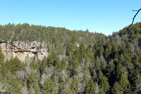
There were at least 10 overlooks accessible from the South Rim Trail.
The quality of the overlooks varied from just a lookout through some trees to five star - sit all day - views.
Stage Road Campsites were just another one of the great backcountry facilities at Savage Gulf.
The actual location of the Stage Road Campsites was a bit off on the Savage Gulf map (available at the Ranger Station or online). We corrected the location on our map.
The trail distances also needed a bit of changing because the campsites were not properly placed. We also changed the overall distance of the trail from 4.80 to 4.60.
If you visit all of the overlooks, it adds a mile to the overall distance!
I used the Avenza PDF Map app on my iPhone (also available for Android). I kept a good GPS signal even though I had no cellular service.
Treat yourself to a premiere hiking destination and visit Savage Gulf. We are excited to hike the North Rim and North Plateau Trails, soon.
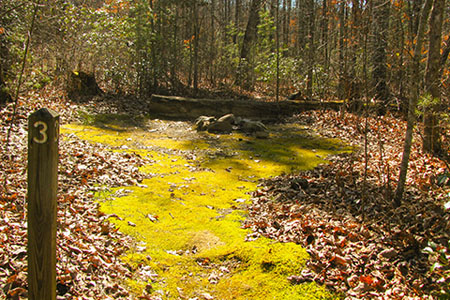
Site #3 at Stage Road (total of 10 sites)
Happy South Rim trails
cloudhiking.com 's Savage Gulf Trail Map