| 605 | More Fall Creek Falls Trails | 2012-03-22 |
At cloudhiking, our map and guide site, we are working on a Fall Creek Falls map and, possibly, a guide. Fall Creek Falls is a big area in the center of the state. We have three maps already on cloudhiking: Gilbert Gaul Trail, Day Hike Trails, and the Upper Loop Trail. All of the maps were in the old style. We are now trying to make one big map with all the trails, and in the new style.
We still had a few pieces of missing data to complete the map and went to Fall Creek Falls yesterday to complete the missing pieces. It was a hot summer-like day, even though the calender said March.
Our first hike was, the Chinquapin Ridge Mountain Bike Trail. It was a great hike along old roads in the south area of the Park (The trailhead is off Hwy 284). We did not see anyone along the 5.35 mile trail. The trail is designated as a mountain bike trail, but also is a great hike and would be a super trail run.
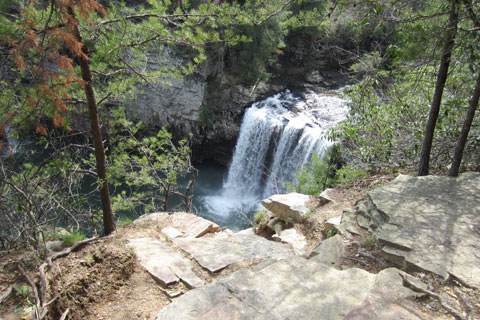
After finishing Chinquapin Ridge we drove around a bit (there were also some roads we needed to check out) and ended up at Fall Creek Falls Parking Area. Carrying only the GPS for the short hike, we descended to Fall Creek Falls and returned to the overlook. We already had this trail, but to be honest, we were trying to get an even better track. By using multiple tracks, we are better able to see the trails' path and that always increases accuracy.
From the Fall Creek Falls Overlook we hiked on the Woodland Trail to the Scenic Overlook Loop, stopping at each one. We had a good track on the Loop but not the overlooks.
Returning to the Woodland Trail we followed it to the Nature Center. Remember, we only had our GPS and camera with us ... so, by the time we reached the Nature Center we were hot. The fountains were not working, but the restrooms were open and we scooped water from the faucets.
After drinking a few handfuls of water we continued on the Paw Paw Trail to once again visit overlooks. The three overlooks are open and panoramic and well worth the side visits.
Returning to the vehicle at Fall Creek Falls we went to another mountain bike trail near Group Camp 2. Parking at the Gilbert Gaul Trailhead we took the mountain bike trail past the camp and followed the old roads to Backcountry Campsite #2. The road was a pleasant walk but did not have many attractions. At least it was cooler as we finished the 6.5 mile out and back hike. We did not see anyone on the trail, but did see a hiker at the backcountry camping area.
It was a good day and adventure as we returned to the vehicle thirsty after a hot day on the trails.
Happy more Fall Creek Falls trails
cloudhiking guides and maps to Fall Creek Falls
Gilbert Gaul Trail Guide - Map
Day Hike Trails map only
Upper Loop map only