| 151 | Montgomery Bell Park, Tennessee | 2009-11-16 |
My hike of the week took me to Montgomery Bell State Resort Park. Located 40 miles to the west of Nashville on Highway 70, the Park is nestled between between White Bluff and Dickson. Montgomery Bell is a resort park so it has a hotel, cabins, camping, swimming, golf, and many other amenities.
Jake, my dog, and I parked at the Visitors Center close to the Hwy 70 entrance. We did not park at the actual trail parking area and therefore had to do some minor wandering before we located the trail. The Montgomery Bell Trail is the overnight trail. It is an easy grade and rated as moderate, for its duration. However, do not be surprised to find a few short steeper sections of trail. The white blazes and signage made the navigation easier; but we had trouble in places due to trail concealment. A sea of oak leafs were knee deep in places and left the trail indistinguishable. Jake used his nose to keep us on the right path. We were just lucky a varmint had not passed that way recently, no telling where we would have ended up.
The Montgomery Bell Trail basically follows the Park boundary. We started in the north and headed east toward the Wildcat Shelter, one of the three overnight lean-tos. As the trail heads southeast toward the eastern border, construction was encroaching on the trail’s view shed.
After following the good trail for a mile further, the path joins an unimproved road. The trail runs in conjunction with the road for over a mile along the edge of the golf course. The road is easy walking, but it seemed deprived of blazes. (The road was so easy to follow, who would need a blaze?) As my mind was wandering, I wondered if I had missed the trail junction. There was no need to worry though, the intersection was a very obvious, well signed, turn to the right.
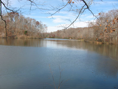
Off of the road, the trail headed toward Creech Hollow and a trail junction. A major sign gave mileage information. We turned left and continued on the Montgomery Bell Trail as it climbed out of the hollow and intersected with the Jackson HIll Road. Another quarter of a mile of hiking brought us to the intersection with a side trail that led to the Woodland Shelter. Continuing on the main trail, it crossed a couple of bridges and went to a point overlooking Lake Woodhaven. Shortly after the lake there was a boardwalk that went to the right of the path. The boardwalk was not part of the trail system, instead it was a nature observatory.
From the boardwalk it was less than a quarter of a mile to Hall Spring and Shelter. Leaving the shelter an old road followed the western edge of the Park. Urbanization was very close to the trail as it passed the Hall Cemetery Road. The road crossed a creek and continued to a junction with a wide path coming from the group camp area. A hiking rest station was at the junction. From the rest station is was downhill to Jackson Hollow and the creek. We followed the picturesque creek to the historic church area. Crossing the creek on a bridge we turned left and followed the creeks other bank a few hundred feet until reaching the trailhead for the Ore Pit Loop. The Montgomery Bell Trail followed the Ore Pit Trail for an interesting mile. After leaving the ore pits, we intersected with a paved road. Crossing the road led to another trail shelter, picnic ground, and water - the only source available without filtering or treating. After a brief rest we crossed the bridge and followed the path up a hill, over a ridge, and then down to the group camp road. The Maintenance Office Overnight Parking was just ahead.
We left the parking area and followed a creek upstream to a good bridge. Crossing the spillway creek, we climbed another ridge. which dropped into a steep banked hollow and then abruptly climbed to the Jackson Hill Road. The trail joined the path coming from Creech Hollow on the right and continued to a set of stairs leading down to an ore pit excavation.
With the Visitor Center in sight to our left, we continued to follow the trail as it turned right at a junction with the Wildcat Trail. We followed the trail walking adjacent to the Hotel Road until we came to a swollen creek. To keep our feet dry we crossed the creek on the road and then returned to the trail. (When I walk the trail again, I will just stay on the road.) Heading up a slight hill we crossed the road again in a hundred feet or so. The Montgomery Bell Trail, went back down the road to the left, into a picnic ground, and then followed an old road (to the left) to the old Visitors Center. The loop was done.
A few trail notes...
- It was a good urban trail. Developments are encroaching on all sides of the Park. If the trails could be moved more toward the interior of the Park it would improve the view shed and make it a better trail.
- There were plenty of mileage signs on the east side of the trail, but none on the west side.
- We only saw one other hiker.
- Water and restrooms are available at the Visitors Center. During off hours the campground is also close by. All the facilities were well maintained.
- Oddly enough, someone had painted possible trail hazards orange. There were hundreds of roots, rocks, and stumps covered with an orange coating of paint. I wondered what criteria they used to qualify an obstruction as being a hazard.
The Montgomery Bell Trail is a worthy hike for anyone looking for a longer day hike or overnight trek.
Happy leafy trails.