| 154 | Cumberland Mountain State Park, Tennessee | 2009-11-23 |
For our weekly hike, we traveled to Cumberland Mountain State Park near Crossville, TN. Fourteen miles of trails lay waiting for us and to help us out we had a few friends hiking with us.
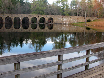
The Park was easy to locate. From any of the Crossville exits off of Interstate 40, go south to reach Hwy 127 (exit 317, the most westerly exit, is Hwy 127). Hwy 127 is Main Street. Head south or east on 127. After passing through town, it is about 3.5 miles to the Homestead junction. Bear right to stay on Hwy 127. The Park entrance is .75 miles on the right. On entering the Park, the Park Office is located on the right before Byrd Lake. Park at the Office or continue across the Dam and park at the restaurant. Information about the Park is available at the Office.
Cumberland Overnight Trail
To hike the Cumberland Overnight Trail you hike all or parts of the Cumberland Plateau Trail (red blazes), the Byrd Creek Trail (yellow blazes) and the Overnight Trail (blue blazes). From the Park Office, turn right immediately after crossing the dam and begin hiking the Plateau Trail, following the red blazes. The Plateau Trail is a nature trail which makes a short loop. The more picturesque leg of the trail goes down the stairs located next to the dam. The trail then follows the creek downstream. It is .45 miles to the junction with the yellow blazed Byrd Creek Trail.
The yellow blazes continue by following the creek. After a short while on the yellow trail, a recent downed tree has made a minor detour away from the creek. Rejoin the trail and continue. At .6 miles on the yellow trail an elaborate bridge (built as an Eagle Scout project) crosses a tributary of Byrd Creek. The trail climbs a hill a short distance to a junction with the blue trail, at .65 miles on the yellow trail.
At the junction, to continue on the Overnight Trail, turn left and follow the blue blazes. To continue on the Byrd Creek Trail go right and follow the trail/old road .15 miles to the Old Highway.
Continuing on the Overnight Trail, the trail heads into the highlands leaving Byrd Creek. The Park did a good job using most of their land for the trail as it closely follows the Park boundaries. After crossing rolling terrain the trail crosses a creek at 1.60 miles on the blue trail. It is only a quarter of a mile from the creek to the camping area. The designated campsite is an exposed slab with a fire ring. We had to pick up trash (thanks Mo) but mostly the area seemed unused. The campsite is 2.95 miles from the Byrd Lake Dam. The icon is not correctly indicated on the Park’s Trail Map. A permit is required to camp overnight. Hey, keep it clean!
From the campsite continue on the blue trail .6 miles to reach the turnaround spot on the trail. An unmarked trail goes to the left at the tee and the marked Overnight Trail veers to the right. Turning right, the trail crosses the top of the ridge for about .8 miles then drops down to the north into the Three Mile Creek drainage. Three Mile Creek is crossed after gradually descending .35 miles. The trail crosses a couple of tributaries and then a swinging bridge which spans Three Mile Creek after 1.5 miles. From the bridge the trail climbs a hill and then descends to the junction with the yellow trail after .6 miles.
At the junction turn left (right takes you .15 miles to the start of the blue trail.) The Old Highway is just a few feet away. Turn right on the Old Highway and cross Byrd Creek. Then re-enter the woods by turning right after only a short distance. Following the yellow blazes the trail follows Byrd Creek back toward the Park Office. After .35 miles a small creek is crossed. The trail then contours between the campground and the creek and after .85 miles the Byrd Creek Trail exits the woods at the Office.
The lengths of the trail are as follows: Red Trail - .9 miles, Yellow Trail (with one leg of the Red Trail) - 2.45 miles, Blue Trail (with one leg of the Red Trail and the two legs of the Yellow Trail) - 8.0 miles.
After a brief rest and lunch we were walking again to do the Pioneer Loops. These section of the trail are more traveled than the Overnight Trail.
The Pioneer Loops
Starting at the Park Office cross the road and head south along the east side of the lake - opposite the restaurant. The orange blazed Byrd Lake Trail follows the shore to connect with the Pioneer Loop at the bridge. There are some great photo-ops of the dam along this trail. A creek is forded after .4 miles and the large bridge at the boat dock is at .6 miles from the road.
At the bridge, the Pioneer Short Loop begins. The white blazes continue to follow Byrd Lake to the swinging bridge. After .2 miles a creek is crossed and after another .2 miles a rock bluff overlook can be seen on the opposite bank of the lake. The trail is now sandwiched between the lake and the golf course. It is .4 miles to the next creek and then the swinging bridge is another .2 miles away. This leg of the Short Loop was 1 mile.
Cross the bridge to continue on the short loop or begin the Pioneer Trail blazed with green markers.
The trail follows the upper Byrd Creek to the Old Mail Road and bridge. There are a number of rock house features along this section of trail. After crossing a couple of small creeks, go through the Fat Man’s Squeeze rock formation at .7 miles. Cross a couple of more creeks and reach the road in another .85 miles. From the swinging bridge it is 1.55 miles to the road.
Go onto the road, cross the bridge and then return to the trail. Be sure to look at the bridge construction, it is quite impressive. The return trip seemed faster. After .75 miles a creek is crossed followed by another after only a short while. The swinging bridge is reached at .9 miles.
Rejoin the Pioneer Short Loop (white blaze) and continue following the creek and headwaters of the lake. After .55 miles the small rock bluff seen from the trail on the other side of the lake is reached. This is a great place for a small break. Hiking another .35 miles is the boat dock and bridge. The boat dock is .9 miles from the swinging bridge.
From the boat dock either continue hiking on the same side of the lake or cross the bridge and finish on the Byrd Lake Trail. To continue on the west side of the lake, follow the road for a hundred feet and then cut off to the right behind the old bath house. Return to the lake in front of the restaurant and walk to the dam. Cross the dam on the road and return to the Park Office.
The lengths of the trail are as follows: Byrd Lake Trail (orange) - .6 miles, Pioneer Short (white) - 2 miles (crossing both bridges), Pioneer (green) - 2.6 miles (crossing the bridge), the walk in front of the restaurant was .25 miles. The total roundtrip was 5.30 miles.
Some brief trail notes:
- The Cumberland Plateau and Byrd Creek Trails were good, easy to moderate trails.
- The actual Overnight Trail was moderate. It needed some love. One bridge had been smashed by a tree making for an awkward crossing. Several other trees were down on the trail. The growth along the sides of the trail was aggressively approaching the path.
- The camping icon is in the wrong spot on the Park Trail Map.
- We saw no one on the Overnight Trail.
- We saw hikers on all of the other trails.
- All the other trails were in better condition than the Overnight Trail.
- The Pioneer Trails were interesting, fun walks. They were rated as easy to moderate. Footing was the only difficulty.
- The Park facilities were well maintained.
- Water and restrooms are available at the restaurant or the Office.
- The trails were well marked and signed. They were easy to follow.
- We stayed at the Mill House Lodge - what a great place.
Special thanks to Mo, Amanda, Ray, Laura, Jon, Nancy, Paul, Jenny, David, Amy, Copper, Coda, Dixie, and Jake for a great weekend and fun hikes.
Happy trails.