| 492 | cloudhiking news | 2011-10-07 |

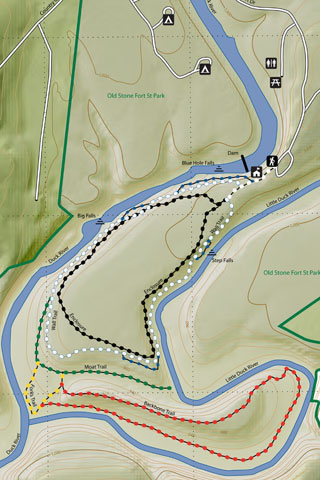
Finally, we put a new map and adventure guide up on cloudhiking. It has been since JUNE; but Old Stone Fort Trails and Old Stone Fort Alternate Trails are now completed.
During the summer I was hoping to work on maps while we were in Colorado; but that just didn't happen. I needed too many resources and a big computer. My little MacBook tried, but he was just under powered.
When we returned to Tennessee we updated our desktop computer and mapping software. The software was supposed to allow us to make better maps; but the learning curve was steep.
Last night we shared the map with our friend, Jon. After a few "could you add" suggestions, the map was complete. We celebrated.
So what is different ...
The maps are geo-referenced. They can actually be used for navigation. The old maps looked similar; but they did not have a scale or a coordinate system. The old maps were basically a pretty hand sketch. On the new map, every object has coordinates. It's pretty exciting!
We also added a shaded terrain as a background.
A grid is included, giving longitude and latitude.
A scale is also on the map.
We took off the mileage markers, but they might return on other maps.
The maps should be easier (faster) to make; after we practice a bit more with the software.
A lot of love still goes into each map.
The maps are still designed to be viewed electronically. Therefore, there is little concern for the dimensions of the document. We can make the maps for print on request (but, you have to say please! : ) )
We hope to have the maps and some form of the adventure guides as smart phone/tablet applications, soon.
Thank you for all of the support. We are a small site; but with your help we will continue to grow.
Happy cloudhiking map trails