| 608 | Chinquapin Ridge Trail | 2012-03-27 |
In the late '90's the Chinquapin Ridge was made into a mountain bike trail. The trail is located in the south section of the park in a relatively unused area. Old fire roads were made into the "trail."
From the trailhead on Highway 284, a quarter of a mile west of Piney Creek, the trail descends steeply to a field and less steeply to a bridge crossing Meadow Creek. The bridge is also used by the Upper Loop Trail ( a dual use - hiking and mountain bike trail.)
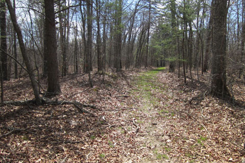
From the creek the trail climbs Chinquapin Ridge. When we hiked the trail, it was mid-March and the leaves were just budding on the trees. As we climbed the ridge we could see down from either side of the ridge. It was also unseasonably hot, but a nice breeze kept the ridge cool. It was quite idyllic.
The trail follows the ridge for two miles from Meadow Creek before it turns left at a sign (the old road that the trail had followed continues). From 1800 foot elevation, the trail drops 200 foot in a little over a half mile to a creek crossing near Piney Creek. The trail does not actually go to Piney, but comes very close.
From the creek crossing the trail follows along side creek for a short distance before climbing through a wonderful tunnel of Mountain Laurel. Out of the tunnel-like greenery, the trail continues to climb gently to rejoin the ridge section of the trail. The trail made a classic lollipop route - a loop at the end of a straight section.
From the junction with the trail on the ridge, turn right and follow the old road for about a mile to return to the trailhead.
Our total mileage was 5.30 miles. It was a very enjoyable trail.
A few trail notes ...
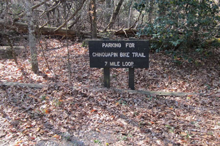
The trailhead was easy to find, but parking was limited.
Even though the trail is a mountain bike trail, it makes a good hike and would also make a good run.
The trail is not blazed, but signs clearly mark the path and all of the turns.
There are no facilities or water at the trailhead.
The trail is not 7 miles long. We walked the trail in a little less than 2 hours and the GPS indicated 5.3 miles.
If riding the path, the trail would be suitable for beginners to intermediates. I think I would let out a wahoo or two on the easy, but fast downhills.
Hikers should watch for bicyclists and allow them to safely pass. It is their trail!
We had Jake, the dog, with us and he loved the trail.
We did not see anyone else on the trail.
The area is hunted in the fall and winter. Check with the Park for possible closures.
We didn't see any litter on the trail. The trail was also in very good condition.
Whether you walk it, run it, or bike it, the Chinquapin Ridge Trail is not to be missed on you visit to Fall Creek. It is not far away, but far enough away from the maddening crowds to be very enjoyable.
Happy Chinquapin Ridge trails