| 242 | Black Mountain Loop Trail | 2010-06-16 |
Yesterday, we went to Black Mountain to meet our friend Ray. We planned to do a little rock climbing and to also hike the Loop Trail. Ray was late, as usual, even though we were meeting at a very casual time of 11. We decided to go ahead and hike the Loop Trail without Ray.
It was very hot and humid and storm clouds were approaching as we left the parking area. A paved path led a few hundred feet away from the parking. Where the pavement ended, a sign (Main Trail) directed us to the right. It was a short walk to the Spring House and cabin remains. Steps led from the spring as the trail climbed a hundred feet to the kiosk. An area map was posted on the kiosk.
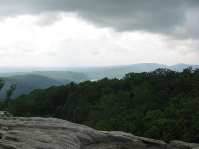
Leaving the kiosk the trail climbed to the top of Black Mountain. The trail leveled and the South Overlook spur was to the left. It was definitely worth the walk to the overlook.
As we returned to the Main Trail, the storm began. Jake, the cautious dog, immediately turned and tried to bolt to find a safer location, presumably the truck. Amy's hand was still in the leash as he tried to drag her with him to a safe place. It took a few minutes for Jake to settle down. It thundered for the rest of the day.
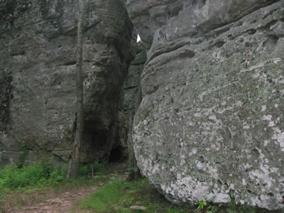
Continuing the trail we came to a junction. The Cumberland Trail went left down a steep set of steps between two rock walls. The Loop Trail continued straight and wound around to the north side of the mountain and to the North Overlook, another side trail. The overlook was a short distance from the Loop Trail, but in the summer did not have much of a view due to the tree canopy.
We returned to the Loop Trail and walked downhill. The trail crossed the road and after climbing a few steps, re-entered the woods. The Loop Trail rejoined the Cumberland Trail in a few hundred feet. The junction was unmarked.
After a short climb the Loop Trail ended on the paved path. The junction was unmarked.
We sat around and waited for Ray in the truck. Jake was happy to be in a safe place as it continued to rain and thunder.
A few trail notes ...
- Black Mountain is located about fifteen minutes south of Crab Orchard at exit 329 of Interstate 40.
- The Main Trail and the Cumberland Trail are the same trail.
- The Cumberland Trail used white blazes.
- The Loop Trail was not blazed.
- When hiking the Loop Trail, another great side trail would be to take the Cumberland Trail down the steep steps between the rock walls. The trail weaves through a couple of large rock formations before heading downhill.
- The cliff line continues beyond the trail almost continuously to the Spring House.
- The South Overlook is grand.
- There are radar and communication towers on the mountain. The utility lines power the installations. The radar installation is on the very top of the mountain, the communication tower is at the parking area.
- The Loop Trail was overgrown once it left the Cumberland Trail. Briars, thorns, thistles, and poison ivy encroached and even covered the trail.
- It was very hot and humid when we hiked the trail.
- The Trail would probably be a better hike in the fall, winter, or early spring.
- By the way, it thundered all day. The booms were continuous.
Ray, Craig, and Kaylee finally arrived. The rain held off until close to 5. We were able to spend the rest of the day climbing.
Happy hot, muggy, and overgrown trails.