| 765 | Bells Bend Visit | 2013-02-01 |
In the Fall we were contacted by Bells Bend Park and asked if we would modify the Bells Bend Map to match an Eagle Scout project. We did not even question the changes, we immediately said yes.
Then, a short while back, we heard from the Scout, Jonathan, that he had completed the project. He kindly asked if we would modify the colors of the trails on the map to match the signage he had installed on the trails. This was a worthy Eagle Scout service project. We were pleased to help.
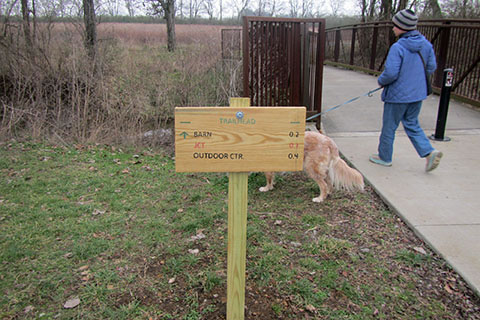
Bells Bend Park in Nashville, is located on an old farm along the Cumberland River. Though the land is not farmed any longer, it still is farm land. The trails of the Park are merely mowed swaths through the fields (some have been improved with gravel). For as long as we have visited the Park, there have never been trail signs. The Park has instead offered free maps to help the hikers navigate the trails.
Though we never spoke with young Jedi Scout, Jonathan, we could just imagine the planning and work involved with the seemingly simple task of providing trail signs. There are two trailheads, 7 trails, and 13 junctions. Wow!
With the request to modify the map, Jonathan also sent a mock-up of the new colors for the trails. Before we changed the maps, we decided to visit the Park and actually see the signs. We really didn't need an excuse to visit the Park, but having an excuse, gave us a destination for Sunday.
Our aging Golden Retriever joined us. Amy and Jake went for a short hike and visited the creek close to the trailhead, while I sped around the Park's trails taking photos of the new trail signs. As I walked the trails I noticed that the path showed more tracks from machinery (maybe tractors, etc) than normal. The trails were very muddy. I continued on the loop toward the river.
Along the river, the path was in much better condition. Then as the path left the river I was surprised to find a new body of water. Someone had built a new pond. The area was a drainage and often times held water, but this was more. It was a real pond with a dam and ducks!
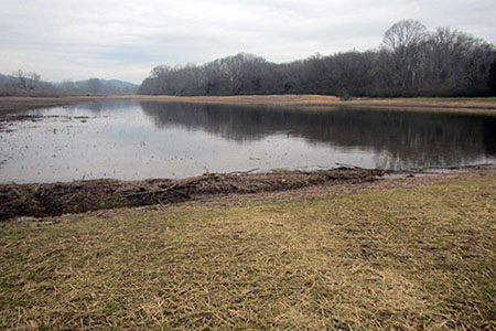
'Test Pond'
So that was why the trail was muddy. The equipment used to work on the pond had used the trail for access. Ha!
(Oh, I asked about the pond, and found that it was a 'test pond'. I think the primary purpose was to provide wetlands for birds and critters.)
We returned home and finished updating the map this week. Oh, the test pond did not make it on the map, yet. We decided to pretend the pond does not exist until the "test" status is removed, then we will add it to the map. The pond is near the eastern junction of the Loop Trail and the Old Farm Road. See the cloudhiking map.
Congratulations to Scout Jonathan on completing his Eagle Service Project.
Happy Scouting trails
Bells Bend - cloudhiking pages
Bells Bend - Metro Parks page