| 698 | Barfield Map Update | 2012-09-03 |

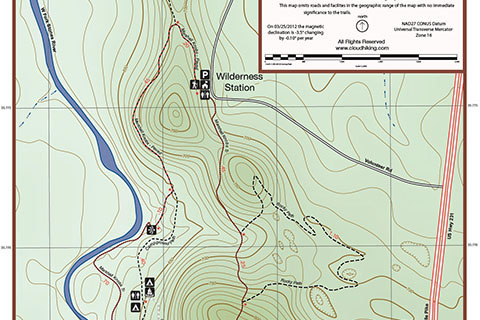
A screen shot of a section of the new map
We (cloudhiking) have completed an update for the Barfield Park Map (the map is on Page 2). We have been working with the Barfield Park Wilderness Station on a display map for some time now. During the process we made a new Barfield map. Yes, it looks very similar to the old map, but it should! The old map was correct, the new map just adds some bells and whistles. Hope you enjoy the map.
Downloading the map to an iphone, ipod touch, or ipad ...
- Install the free app - iBooks
- Browse to the map's web page on your "smart device"
- Once the map is open in your smart phone window, tap near the top of the screen, you will be prompted to "Open in iBooks"
- The map will be stored in iBooks PDF's Collection
- For Android or other smart devices - use the Adobe Acrobat Reader or do a quick search for PDF and your device
A few of the updates ...
The map is now completely geo-referenced. Each feature of the map is tagged with it's coordinates.
A shaded relief image was added to the background to help with the visualization of the terrain.
The Latitude and Longitude grid was added. The grid interval is set to degrees and decimals. Set your GPS's "position format" to match the maps as hddd.ddddd° (meaning the degree (35) and a decimal (or fraction) of the degree (.775) would read 35.775. This method seems easier than reading minutes and seconds.) Some use the World Grid, UTM coordinates, but is often times confusing.
A scale has been added to the map. The map had mileages on all the trail segments, but a scale might also be helpful.
The declination data is included. This information answers the burning question, where is magnetic north going to be next year.
Emergency numbers are also included.
The Barfield Park has some great trails. A day at the Park makes a great mini-adventure.
Happy Updated Map trails
cloudhiking's Barfield Park Trails