| 376 | Trip Planning | 2011-04-14 |
We have decided to go to Colorado for our summer trip. For a while we were leaning more toward Montana and Wyoming; but we finally decided on staying closer to home due to the gas prices.
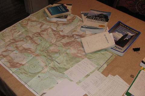
After deciding the state, we next chose the area. Basically, we decided to go to Rocky Mountain National Park. We have work to complete in the area. We are trying to record enough information to do a cloudhiking guide of the area trails and mountains.
Our plan is to spend a week in the Wild Basin area, south of Estes Park, a week in the Mummy area, north of Estes Park, and a week on the west side, near Grand Lake. Then, we will meet up with some friends for one week in the Park and then one week in the Front Range, treating our friends to a few special places we have found.
To prepare for such a trip, we write each potential destination on an index (three by five) card. Information includes destination, trailhead elevation, destination elevation, mileages, waypoints, and secondary destinations. Once the cards are completed, we will then put the cards in the order we are hoping to hike or climb them.
Due regard will be spent trying to decided how hard each day will be on us physically. We can plan on conquering the world while sitting at home; but when we in the field, if we have not planned carefully, we will grow tired or even injure ourselves trying to keep the schedule.
Well, why not just wing it? Our times in the mountains are important to us. We are visiting Colorado for 5 weeks; but we have a lot to do in those 5 weeks. If we are not organized we might be disappointed.
If you are taking a trip this summer with specific goals, we would recommend a strategy similar to the one we are using...
Pinpoint general areas to visit - Rocky Mountain National Park (or Smokies, tour of western states, tour of Tennessee, Orlando, etc.)
Pinpoint attractions - Mount Alice, Thunder Lake, Ptarmigan Towers, etc (or Mount Le Conte, Clingmans Dome, Abrams Falls, Gregory Bald, etc)
List the specifics of each attraction - Wild Basin Trailhead elevation: 8500 ft; Thunder Lake Jct: 10000 ft, 4.5 miles; saddle: 12120 ft, 8 miles; Mount Alice: 13,310 ft 8.8 miles (or Rainbow Falls Trailhead: 2600 ft; Rainbow Falls: 4200 ft, 2.7 miles; Bull Head Trail Jct: 6000 ft, 6 miles; Mount Le Conte: 6593 ft, 6.95 miles)
Rank for importance - Separate the "must sees" from the "it would be nice if we have the time". We have to climb Mt Alice; but Mount Orton is not critical (We have to climb Mount Le Conte; but Clingmans Dome is not critical).
Place the index cards in order as to when you hope to visit each attraction.
Re-look at the specifics, question the order of the cards. Don't plan two killer days in a row.
Keep the cards with you on the trip. Re-order the destinations as needed. Undoubtedly things will change as the plan becomes operational. You will have "I am too tired days" - more commonly called rest days and you will also have bad weather days.
The goal of the planning is not to set in stone the goals; but to plan for change.
You could also shuffle the cards of similar difficulty and draw for a random destination.
If you need a couple of easy days in a row, look at the card's specifics to find some easier days.
If you are planning a trip with specific goals, then plan for success. Plan adventurous goals and then train for the goals.
Happy planning trails
See you in Colorado? : )