| 964 | Summer Stories What a Great Trail! |
2014-11-23 |
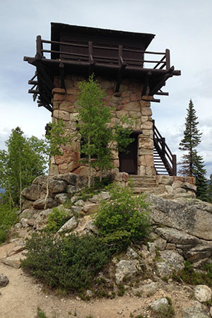
Fire Tower on Shadow Mountain
While visiting Rocky Mountain National Park in June ('14) we camped for a short while on the west side of the Park. One of the most recommended day hikes in the west side of the Park is the Shadow Mountain Trail. Starting within the town of Grand Lake, the trail follows the shore of Shadow Lake and then climbs to the fire tower on Shadow Mountain.
The day before our hike, we drove to town and found the trailhead so that we would know where we were going the next morning. There is a new East Shore trailhead which is located on National Forest land. We had not even taken a step on the trail, but had already formed a favorable impression.
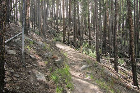
As we drove into the parking area to start the hike, two foxes crossed our path. We smiled as we watched them scamper along. Our hike started at an easy eight o'clock, but we still had the trail to ourselves. The map had shown that it was 0.70 mile to the junction where the Shadow Mountain Trail left the East Shore Trail. Even with stops and a leisurely pace we were expecting to be at the junction in about thirty minutes.
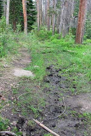
Muddy Trail
It's always fun to hike new trails, but shortly after starting the hike we found the East Shore Trail littered with downed trees. Many detour trails ventured around the temporary blockades. When we were not avoiding trees, we were jumping mud puddles. Water was standing on a good portion of the trail. Our rosy expectations of the trail were quickly tainted.
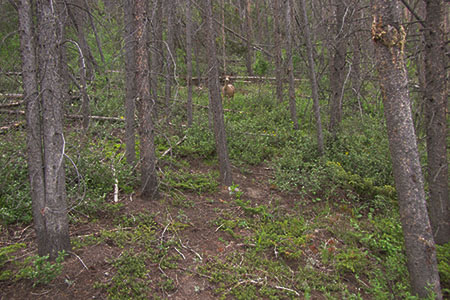
Deer who suddenly stopped in his tracks - when he saw us
On the brighter side, the trail was flat and easy. I was concerned as we continued to walk beyond thirty minutes (my predicted ETA), that somehow we missed the junction. A couple of significant notes: we did pass through an osprey nesting area and as we passed at the base of a steep slope, a young deer bolting down the hill was truly surprised by our presence. Still, the trail was in terrible condition and more importantly, something was wrong with the mileage on the map.
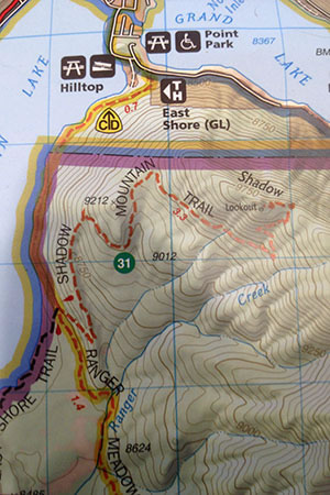
The 0.7 mile distance - was actually 1.6 miles. Oddly, the trail that connects with the Shadow Mountain Trail is not even noted on the map. I assumed the 0.7 was the distance, but the map doesn't even indicate the total distance.
Stopping to check the map, we couldn't figure out why the map had the wrong mileage. The trusted map was marked as 0.7 but for some reason the trail stopped at the National Forest and National Park boundary. We had been walking close to forty-five minutes and had walked further than a mere 0.7 mile. Continuing, the junction was a short distance away. (We later found the distance to the junction to be 1.6 miles.)
Climbing above the lake to the ridge
Leaving the East Shore Trail the Shadow Mountain Trail climbed to a ridge and then on to the upper sections of the mountain. The hike which started so poorly for us, improved with every step. It was a great climb with good views in all directions and then it got even better - rickety stairs climbed to the upper fire tower porch. What a view! The East Inlet, North Inlet, and Tonahutu drainages of the Park were obvious to the east and north, and to the west were the lake. The view was worth the effort.
As we returned to the trailhead, we passed many hikers. On the easy East Lake Trail (you know the one that had all the downed trees and mud holes) we met two women hikers. We stopped for a brief moment to talk to them. They exclaimed, 'what a great trail', and generally thought the trail was just the best. At first I thought they were being facetious, but no, they really liked it. Hmmm.
While we thought the East Lake Trail was the only bad section of the route to the fire tower, the women felt that it was the best ever! I am sure that with a little trail work the trail condition would greatly improve, but as it stood, the obstacles took away from the beauty of that section for us. Maybe, the trail was - actually the best ever for the women. Maybe, they had not hiked many trails or maybe, their criteria for a good trail was absolutely different than ours. We were happy for their energy and opinion and we were also happy that we had hiked to the upper mountain and the fire tower. We thought it was a great trail too!
Happy What a Great Trail - trails
link - Rocky Mountain National Park
other notes ... we are almost finished with a new map for Savage Gulf in South Cumberland State Park (TN). We are also working on a map for Pogue Creek Natural Area (TN) and Paintbrush Canyon (Tetons). These maps are in various stage of completion.