| 816 | Mount Ida Map and Guide |
2013-05-31 |
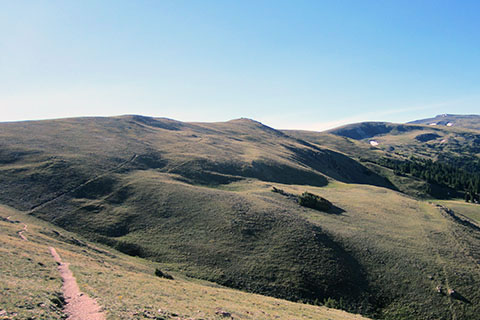
Mount Ida sits at 12,880 feet on the Continental Divide in Rocky Mountain National Park, CO. Last summer (2012) we re-hiked the trail to collect data for the map and guide for cloudhiking.com. We had a great day on Ida and wrote several stories about the hike and the hikers we met. Yesterday, we finished the map and guide!
The mountain is popular for many good reasons:
easy access - the trailhead is located on Trail Ridge Road
moderate climb - the route gains about 2000 feet in 5 miles
elevation - the route starts high (10,759 feet) and does not have huge elevation gains
great views - most of the route is above timberline as the route crosses the alpine tundra
recommended - Ida is listed on the list of the Park's suggested summit hikes
A few notes on the Mount Ida map and guide ...
The mileage to Mount Ida was listed as 4 miles on a sign post near the trailhead. We are not very confident in the accuracy of that distance. Our raw GPS track was 5 miles. The route path as measured by the mapping software was 4.75 miles. An extra mile each way might be an extra hour (or more) for most hikers and could be the difference in being dry or being wet and cold.
The route is actually called the North Ridge of Mount Ida.
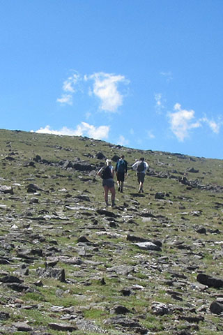
After the first mile the trail leaves the forest and enters the alpine tundra. Please practice minimum impact usage and step lightly.
Always bring rain gear, food, water, a warm layer, map, compass, sun glasses, plenty of sunscreen, and as always the other essentials.
Practice good judgment, turn around if the weather is threatening. The high alpine tundra is not a good place to be during a thunderstorm.
Carry all your water with you, there are no water sources along the route.
At the junction with the Old Fall River Road (the trail that goes to the Alpine Visitors Center) a warning sign is posted. It seems that on the return hike from Mount Ida some hikers lose their direction. Remember the route basically stays high and follows the Continental Divide all the way to Milner Pass. While hiking out to Ida, turn and take a visual of the route in reverse. Carry a map and know how to use it.
An unmaintained trail is followed most of the way to Mount Ida. Cairns (rock piles) mark the last section of the route. See cloudhiking for more info.
The final 1.3 miles of the route are the most difficult.
Practice alpine starts, leaving the trailhead early and plan to return to treeline before noon.
It takes more than an hour to drive from the east side of the Park (Estes Park) to the trailhead in the morning and much longer to drive back to Estes in the afternoon.
We hope to add the route from Timber Lake to the summit of Mount Ida this summer.
Mount Ida is a very good hike and a great destination. We are happy to add it to our Rocky Mountain Park maps and guides. Enjoy.
Happy Mount Ida Map and Guide trails