| 435 | Longs Acclimating | 2011-07-11 |
Amy, my wife, did well on Lily Mountain but she wanted to push a little harder. She has a heel injury and on Lily Mountain she wore her special low heel impact boot but it was not designed for mountain travel. Since we were camped at Longs Peak Campground,the next day we decided to walk up Longs Peak Trail to treeline. Amy was going to wear her disco blue La Sportiva Trango boots and not her orthotics.
The hike was not going to be about climbing Longs, which we both have done many times, nor any particular destination - we were just going for a hike.
Slowly, we climbed to the Eugina Mine/Estes Cone Trail junction. On this section the trail is wide enough for three people to walk abreast making it seem road-like. The only problem is that the trail has a fairly steep section that, if you think that you are in the fast lane, you will be huffing and puffing soon.
After the junction the trail changes from road status into a trail, filled with loose rocks and at times still steeper.
At over a mile from the trailhead the trail to Goblin Forest backcountry camping sites branches off to the left. The campsites are secluded and close to a beautiful, small brook. The sites are not really situated for climbing Longs since the shorter distance of one mile does not justify the weight carried to the site. However, they are a great short backcountry destination.
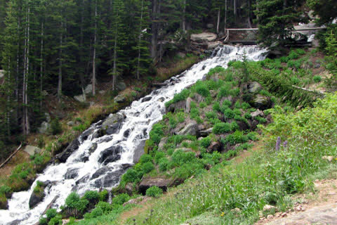
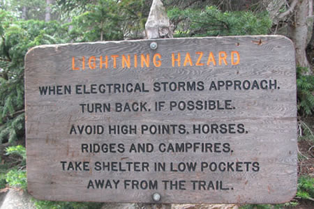
After checking out the campsites, we continued the hike as the trail crossed a normally dry creek bed and then began a series of switchbacks. Soon we were crossing Boulder Brook at a small cascade. A sign at the bridge warned of the dangers of lightning. I did not understand why campfires should be considered a lightning hazard but maybe I will ask someone.
Above the brook, we entered the alpine tundra. Even though we did not go very far, it was still a wonderful excursion onto the upper slopes of the mountain. The tundra is a fragile but sturdy land of alpine wonder. We stopped at our high point for a few minutes and then headed down the mountain.
Soon we met a family with two small children. They wanted to know where the lake was they were wanting to see. We explained that the lake (Chasm) was up on the mountain but it had a steep snow slope to cross that would probably be unsafe for small children. They continued up the trail.
Further down the trail we met a hiker/climber with a bulging pack. All his gear and clothing looked brand new. He was followed by six other hikers all with ice axes, helmets, ropes, crampons, and big boots dangling from their packs. They were low on the mountain but they already felt the weight of their inexperience. We did not speak with the group - they were in misery but we could easily read the story of their hike from the pained looks on their faces.
Our hike ended a short while later. Longs Peak is a great hike whether you are going to the summit via the Diamond (a large, technical face) or just walking up the trail until you grow tired. All the efforts are climbing on the mountains.
A few Longs Peak trail notes ...
Restrooms and water are available at the trailhead.
An important information kiosk is available at the trailhead that gives the latest trail conditions.
Parking is sometimes difficult.
Sometimes parking is available in the afternoon after all of the early morning hikers are back at the trailhead.
A typical summer summit attempt might start as early as midnight; but most start around 3 am. The hike to the summit is 16 to 17 miles and takes most folks between 12 and 16 hours.
As always, watch for the weather!
Happy Longs Peak trails