| 638 | Hallett Peak Map | 2012-05-08 |
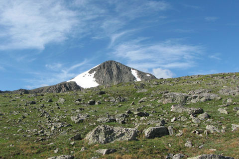
Hallett Peak from the upper slopes of the Flattop Mountain Trail
Over the weekend, we (cloudhiking) finished the Hallett Peak map - Rocky Mountain National Park, Colorado. The map includes the Flattop Mountain Trail to the summit of Flattop and the West Slopes route to the summit of Hallett Peak. Bonus coverage also includes the maps of Nymph, Dream, and Emerald Lakes on the Emerald Lake Trail and Lake Haiyaha Trail from Dream to Haiyaha lakes.
Starting from the popular Bear Lake Trailhead (9475'), the Hallett Peak climb follows the Flattop Mountain Trail. The trail passes the Bierstadt Lake Trail Junction, the Odessa Lake Trail Junction and then climbs the gentle east slopes of Flattop Mountain. Great views to the south are available from the Dream Lake viewpoint, Emerald Lake viewpoint, and the hitching post.
After 4.4 miles, Flattop is climbed (12,324'). The only problem is, Flattop is not much of a summit. True to it's name the peak's highest point is just a flat area and looks more similar to a pass than a summit. Not to worry, just scan to the south, Hallett Peak stands looking over the Flattop summit and is ready to be climbed.
To continue leave the junction with the west of the Divide trails and trend south toward Hallett. The trail soon will end and a climber's path will continue. After crossing near the top of Tyndall Glacier (this is not a descent) continue to the summit slopes of Hallett. Cairns mark many paths on Hallett. Choose one of the paths and go up!
Climb slow and steady. The summit is close.
The views from the top of Hallett Peak, 12,713', are outstanding. The additional .70 mile from the top of Flattop is worth the effort, weather permitting.
A few Hallett Peak Map notes ...
Parking and deluxe privies are available at the trailhead.
Water is also available at the trailhead, but I do not remember any water sources along the trail.
Road construction on the Bear Lake Road will lead to transportation issues over the next two summers (2012-2013). The road will be closed to vehicle traffic from 0900-1600 (9to4). Buses will continue to operate, but parking to ride the bus will be an issue. Be prepared!
The Bear Lake area is still accessible by trail from the Fern Lake Trailhead or East Portal Trailhead, but it would be a long hike just to get to Bear Lake.
The Bear Lake Trail, the trail that goes around the lake, is not included on the map. We have never walked it! We have no excuse, but we will try to map it this summer.
Often times there is a small snowfield just above the hitching post.
Watch for the weather. The peaks are in the mountains and produce daily thunderstorms.
Just hiking to the top of Flattop is a worthy and very popular goal. On the summit, there are a few nice places to rest on the south side with good views of the North Face of Hallett's and the Tyndall Gorge.
The trail ends on Flattop. The rest of the route is a Class 2, climbing route (no longer a trail and requires using hands, at times). The climb is steeper than any section of the trail, the footing might be loose, rockfall is possible, and the way might be difficult to follow.
To minimize rockfall, keep a good space between hikers.
Practice moving over the loose stones without dislodging any rocks.
Hiking poles would probably make the loose slopes easier to climb and descend.
Hallett Peak is a mountain, the summit is the highest point. Travel in that direction.
Hallett Peak and Flattop Mountain are great climbs to test your mettle before adventuring onto the higher or more difficult peaks.
The climb from Bear Lake to Hallett Peak is 5.1 miles (one way) and 3238 feet in elevation gain. Many of the Colorado Fourteeners take less effort.
Instructions for easy ways to load the map on an iPhone are available on the cloudhiking Maps Page. I would assume Android would have similar Apps.
We will work on the cloudhiking Adventure Guide to the map during the summer.
Enjoy the map and put the climb on your must do list!
Happy Hallett Peak Map trails