| 981 | Guide to The Loch, |
2015-04-17 |
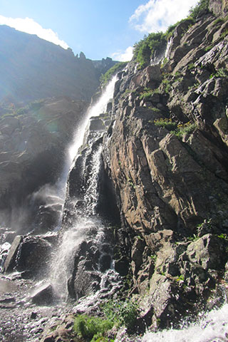
Timberline Falls below Glass Lake
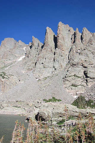
Sky Pond might not be the perfect name for a mountain lake, but none others come to mind that are better. The small mountain lake sits nestled in a cirque of rocky spires and mountains. Reflections of the sky and surrounding peaks dance across the surface of the aptly name lake.
To get to Sky Pond you have to go for a hike. From the Glacier Gorge Trailhead on Bear Lake Road in Rocky Mountain National Park, the trail climbs about .90 mile to Alberta Falls. The falls are wonderful and the crowds are as big as the falls. The path to the falls is wide and mostly at an easy grade (for mountain travel). Fortunately, the crowds usually diminish after leaving the falls.
The trail passes the Glacier Gorge Junction at 2.30 miles and continues toward The Loch. The Loch sits in the gorge named Loch Vale. The Loch is a popular lake at 3.1 miles from the trailhead. A few switchbacks make hikers earn the rewards of visiting the lake.
Leaving The Loch, the trail climbs to Andrews Creek and then on to Timberline Falls. Many hikers stop at the falls rather than scramble up the often times wet rocks to a drainage that leads to Glass Lake.
Good route finding skills (or luck) are helpful in staying on the path as it goes around the north side of Glass Lake. Above the lake the trail crosses rocks, and grasses to finally reach Sky Pond - 4.80 miles from the trailhead. You have to visit the lake to understand, it is truly a Sky Pond.
A few notes about the guide ...
The cloudhiking.com guide has route data, directions to the trailhead, route descriptions, photos, notes from our hikes, mileage, link to area map, and user comments.
The guide is free.
As with most of the Parks' trails, the route was easy to follow. Signs are at each junction, but it is a good idea to stop and read the sign and confirm you are going the correct direction. Often times the destinations on the sign are different from where you are going, but all that might mean is your destination is not listed.
A good trails leads to just below Timberline Falls.
There are no campsites along the route. There is a campsite a short way up Andrews Creek - permits are required for camping.
Sky Pond is a popular destination for climbers, fishermen, and hikers.
The trail can be crowded.
An early start helps to avoid the crowds (at least in the mornings) and the afternoon thunderstorms.
Plan a visit to the Park and a hike to Sky Pond.
Happy Sky Pond trails
Links
Guide to The Loch, Glass Lake, Sky Pond