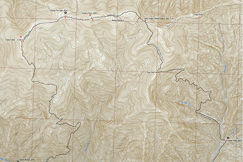
| 906 | Gregory Bald Trail Map | 2014-02-07 |

It's time to celebrate. The Gregory Bald Trail Map is complete. In January I was able to join a backpacking trip to Gregory Bald. The group started the hike in North Carolina from the Twentymile Trailhead.
Our route was to climb the Long Hungry Ridge Trail and then take the Gregory Bald Trail to the summit and to descend the Wolf Ridge Trail back to Twentymile Trailhead. The route formed a great loop hike, but our map includes even more territory. The Gregory Bald Trail Map includes the Twentymile Trail, Twentymile Loop Trail, Long Hungry Ridge Trail, Wolf Ridge Trail, Gregory Ridge Trail, Gregory Bald Trail, Hannah Mountain Trail (partial), Rabbit Creek Trail (partial), and the Appalachian Trail from Fontana Lake to Mollies Ridge. We plan (soon) to hike the Gregory Ridge and Gregory Bald trails to complete the routes to Gregory Bald. We will update the map after completing the trails.
The Gregory Bald Trail Map includes the quarter of a mile trail markers and is also available as a geo-pdf. I carried a rough version of the map on our hike and used it with an iPhone 4s (AT&T). The map had sufficient detail and accuracy for trail hiking navigation and it also was fun. The quarter of mile markers made it easy to determine actual (or really close) distances.
The Gregory Bald Trail Map was another large map and to be honest about it, the larger the map, the harder they are to compile. It is a lot of data and we need your help. If you see something on the map that might be - dare I say, wrong .... please let us know.
Oh, we are working on the guides to the Long Hungry Ridge and Wolf Ridge.
Happy Smoky Mountain Trails