| 817 | cloudhiking's maps and guides of Rocky Mountain National Park |
2013-06-03 |
Last week we finished the map and guide to Mount Ida in Rocky Mountain National Park, CO. It was our seventh map and 6th trail guide!
About 25 years ago I began making regular trips to Rocky Mountain National Park (RMNP). A friend once commented that I climbed more days in the Park than I did at home in Tennessee. It was true. At that time, I was able to work for a couple of weeks and then have a week off. During my time off, I went to the mountains.
When we began to make maps and guides we naturally wanted to make them for the Park. We started with Twin Sisters Peak, then moved across Highway 7 to Estes Cone and Lily Lake, on to Flattop Mountain and Hallett Peak (map only), Deer Mountain, Keyhole Route of Longs Peak, and finally Mount Ida.
cloudhiking.com's maps and guides to
Rocky Mountain
National Park
Lily Lake
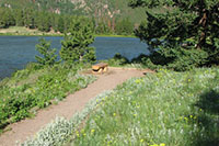 A pleasant stroll around Lily Lake. The .75 mile, Lake Trail is almost flat, but is at close to 9,000 feet elevation. Those visiting the area from sea level might think a few laps around the Lake is enough for one day! There are good views of the surrounding peaks. The Ridge Trail ascends to a bench on Lily Mountain. It is a moderate climb and can extend the loop to 1.30 miles. The Guide ...
Deer Mountain
 Starting at the junction of Hwys 34 and 36 on the east side of the Park, Deer Mountain Trail climbs 1100 feet in 3 miles to the summit at 10,013 feet. The trail criss-crosses the west slope to reach a plateau and then makes one last good climb to the summit. The summit is not above treeline but the lookout offers good views of Estes Park to the east, the central section of the Park, and Longs Peak to the south. The Guide ...
Mount Ida
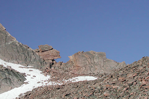
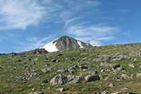
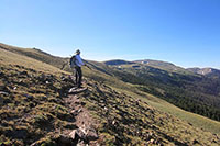 From Milner Pass on the west side of the Park, the North Ridge Route of Mount Ida climbs from 10,759 feet to 12,880 feet in 4.75 miles. The Route follows an unmaintained trail and a cairned route over trail-less tundra to the summit. The Route is above treeline for about 4 miles - each way. Views are of Forest Canyon to the east and the west side of the Park including Grand Lake. The route is graded moderate, but is long. The Guide ...
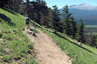
Twin Sisters
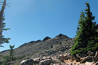 Twin Sisters sits just east of Lily Lake across Hwy 7. The peaks is on the eastern edge of the Park. Starting at 9,200 feet the trail switchbacks for 2.5 miles to a saddle. From the saddle the trail climbs above treeline and crosses a talus slope on a good trail. The west summit, 11,413 feet, is 3.50 miles from the trailhead. Some of the best views of Longs Peak are available from the summit. The east summit (to the left) is a bit higher than the west summit. The Guide ...
Estes Cone
 Starting at the Lily Lake Trailhead, 8,939 feet, The Estes Cone trail climbs to Storm Pass. At the Pass, the trail climbs sharply to the summit at 11,006 feet. Shorter in height and elevation gain than Twin Sisters, the final slopes of Estes Cone are steep enough to deserve a difficult rating. It is a bit of a scramble to the top. From the summit are great views of Twin Sisters and the Valley. The Guide ...
Hallett Peak
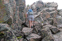
 From the Bear Lake Trailhead (9,450 feet) in the center of the Park, the trail climbs the eastern slopes of Flattop Mountain. After gaining the top of Flattop Mountain (4.40 miles - 12,324 feet elevation) continue to the south and climb the Class 2 slopes of Hallett Peak. The summit is at 12,713 feet and is 5.10 miles from the trailhead) From the summit is a view worth the effort. The trail is rated as difficult. We have only completed the map to Hallett Peak. We need to check a few things on this summers trip before we finish the guide. The Map ...
Longs Peak - Keyhole Route
 Longs Peak is 14,255 feet high. Starting at the Longs Peak Trailhead at 9,400 feet the route climbs 7.4 miles to the summit. The last 1.5 miles of the route is off trail and a Class 3 scramble. The Keyhole Route is the most difficult route listed. Climbers visit Colorado just to attempt it's steep slopes. The Guide ...
We are now, preparing to visit the Park this summer on an extended trip. Among our plans are McHenry Peak, Mount Fairchild and Hagues Peak, Mount Pagoda, Mount Ida from Timber Lake, Kieners on Longs Peak, traversing the range from Bear Lake on the east across the Divide at Flattop Mountain, descending on the Tonahutu Trail to the west, looping around the west side of the Park, and returning to Flattop by the North Inlet trail. These are just some of our goals and hopefully some of our efforts, will be developed into maps and guides. We will continue to add them to the Park's Index.
Happy Rocky Mountain National Park trails