| 190 | Metro Levee - Downtown Greenway | 2010-02-15 |
For our weekly walk we decided to do another greenway section. This one offers scenes of Nashville not ordinarily visible via standard roads.
I had run the Metro Levee Greenway a couple of years ago, but at that time the greenway only went along the Metro Center Levee for 2.75 miles. After searching the Nashville Greenway site we found that the connecting greenway was completed. The total path was supposed to be 5.75 miles.
Parking a vehicle at the Tennessee Titans, LP Field, we drove toward the other trailhead at Metro Center.
Following 1st and then 3rd Avenues, we looked for signs of the greenway along our drive. In Metro Center we turned on Great Circle Rd (going east or back toward i-65). At the I-65 Trailhead, we saw that the Downtown Greenway joined the Metro Levee Greenway. We were excited.
Finding the trailheads can be difficult. Remarkably, there are no signs pointing to either location in the Metro Center. The I-65 Trailhead is basically at the intersection of the Cumberland River and I-65. It is at the end of Great Circle Rd. The Freeland Station Trailhead is at the west end of the Metro Center. From Mainstream Dr turn onto Freeland Station - which is next to the Ted Rhodes Golf Course. There is a dead end sign posted on Freeland, because the road ends at the Trailhead.
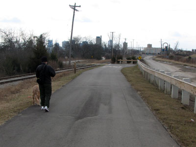
After finding the trailhead, the hike or ride is simple. The greenway is very flat and very easy to follow. There are mileage posts located every quarter of a mile along the path. Starting at Freeland Station the first post is CR ML 4.75 (Cumberland River, Metro Levee, 4.75 miles). Mile 0 is at the north end of Riverfront Park. The posts on the Downtown section of the path are marked CR DT (Cumberland River, Downtown.)
Interesting things you pass: Amulet Lake, Titans Practice Field (seen at a distance), Old Lock One (on the opposite bank of the river), I-65 trailhead, Lone Star dock, Metro’s Biosolids Facility, the spur trail to Morgan Park, Readi-Mix Concrete, spur trail to Bi-Centennial Mall, CSX Railroad Bridge, the Gay Street Connector, and Riverfront Park. We continued along Riverfront Park to the Shelby Street Pedestrian Bridge. At the bridge we crossed1st and then 2nd Avenues and then climbed the stairs to the bridge. We crossed the river on the great bridge and then walked down stairs to our vehicle parked at LP Field.
A few trail notes...
- The Metro Center Trailheads are difficult to find. There are no direction signs to the trailheads.
- The older kiosks have not been updated to reflect additions to the trail.
- The trailheads and kiosks looked great.
- The greenway has mileage posts and benches.
- There are a number of spots to sit and watch the river go by.
- Along the way, river themed art was designed into the path.
- We saw only one other person using the path. He was running on the Metro Center Levee.
- If bike riding, use caution; there was a lot of rocks and sand on the path near the Readi-Mix plant, broken glass closer to town, and a few track crossings.
- The ramp access to Shelby Street Bridge is at 3rd Ave S and McGavock.
- It would probably be faster to ride a bicycle on the path between the Metro Center and Downtown, than it would be to drive.
- It was fun seeing glimpses of the skyline and knowing you were walking to that area.
- There were no restrooms or water along the path.
- Unless there was a breeze on the river, the path would be hot in the summer.
- The web site has not been updated. The map link on the left sidebar takes you to the map page. The Google Maps at the top of the page have the most current information.
- A problem with Google Maps is that if you try to print the page, Google changes the Views from Satellite to Map and the path disappears.
We really enjoyed walking the trail. It would probably be even more enjoyable to ride. We are looking forward to riding from Freeland Station to Percy Priest Dam and back. What a treasure for residents and visitors.
Happy paths.
links - http://www.nashville.gov/greenways/
http://www.nashville.gov/greenways/maps.asp