| 807 | Browns Creek | 2013-05-10 |
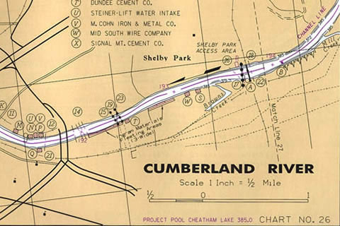
Cumberland River Chart (2000) - Browns Creek and the elbow
Earlier in the week, while listening to the news, I heard of a flooding incident in the Sevier Park area of Nashville. A resident was explaining how the waters from Browns Creek had forced their family to evacuate.
Intrigued I rode over to look for Browns Creek. After seeing the creek (which had receded) it left me wondering if it was the same Browns Creek that flowed into the Cumberland River. Later that evening I did a little research and sure enough it was. I grinned and thought of Captain Poe.
In the mid Eighties I went to work for Opryland USA on the showboat, General Jackson. It was my pleasure to work with three distinguished captains, Bill Howell, Harry Lewis, and EA Poe. During the many hours that I spent with Captain Poe in the Pilothouse, he told me many stories, this one was about Browns Creek ...
The General Jackson was a large vessel and required the Captain to have both a Master's license and a First Class Pilot's license. For the First Class Pilot's license, the Captain had to show his familiarity with the river by drawing freehand the section of river they sought to have endorsed on their license. Captain Poe and Captain Howell did not have the endorsement covering the section of the Cumberland River where the General Jackson would travel. They would have to sit for the extension and draw the river.
They went to Saint Louis to draw the river at the Regional Exam Center. Once in the examination room they both quickly sketched the river, adding the few buoys, docks, and bridges - as they had done so many times before for sections of the Ohio, Illinois, and Mississippi Rivers. Captain Poe handed his finished map to the Junior Officer at the desk to grade.
In a short while the Junior Officer returned to Captain Poe with sad news, he had failed. Among his many errors, Captain Poe had drawn a straight line indicating where Browns Creek entered the Cumberland - well, the creek actually makes an elbow turn. What?!? You can't even get a yawl (row boat) up Browns Creek much less the General Jackson. What difference does it make?
Captain Howell did not even submit his drawing. If Captain Poe's was not good enough, Captain Howell said his wouldn't even stand a chance.
They stormed out of the office and called their friend, the Captain of the Port.
On returning the next day to resolve the issue, they entered the building, loaded for bear. As they stormed down the hallway to the Examination Center, the Captain of the Port met them outside the door. 'Now, now, Captains, here's your licenses.'
The Captains got their licensing endorsements and lived happily ever after. But, there's a bit more to the story.
As the years passed, I sat for my First Class Pilots License. Taking a lesson from Captain Poe, I included the elbow on Browns Creek and I passed.
Steering under the license, I past Browns Creek and often times I thought of Captain Poe. What was always odd to me about Browns Creek was the lack of water flowing from the creek into the Cumberland River. Yet, downstream a little over a half of a mile, a concrete ditch, that I thought drained an industrial area, was often filled with water. After a heavy rain, the flow from the drainage could even alter a small boat's course. The drainage ditch was not on the Corps of Engineers Charts and therefore did not have to be drawn for licensing purposes, but we all knew where it was.
Then, this week when I searched an online map to find where Browns Creek flowed, I saw something interesting. To confirm my discovery, I went to the Corps site and downloaded an updated chart - the drainage ditch, that flowed through the industrial area, was actually Browns Creek. It had been diverted years ago and just wasn't updated on the charts!
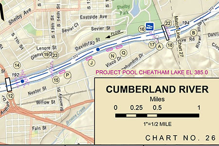
Current Cumberland River Chart - Browns Creek is next to the mileage scale
Ha! I grinned for Captain Poe, Captain Howell, the Junior Officer, the Captain of the Port, and for Browns Creek, what a story!
Happy Browns Creek trails
Charts are from the Army Corps of Engineers